La Cauchie | |
|---|---|
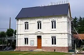 The town hall of La Cauchie | |
 Coat of arms | |
Location of La Cauchie | |
 La Cauchie  La Cauchie | |
| Coordinates: 50°12′05″N 2°34′58″E / 50.2014°N 2.5828°E | |
| Country | France |
| Region | Hauts-de-France |
| Department | Pas-de-Calais |
| Arrondissement | Arras |
| Canton | Avesnes-le-Comte |
| Intercommunality | CC Campagnes de l'Artois |
| Government | |
| • Mayor (2020–2026) | Marie Bernard[1] |
| Area 1 | 2.2 km2 (0.8 sq mi) |
| Population | 209 |
| • Density | 95/km2 (250/sq mi) |
| Time zone | UTC+01:00 (CET) |
| • Summer (DST) | UTC+02:00 (CEST) |
| INSEE/Postal code | 62216 /62158 |
| Elevation | 135–168 m (443–551 ft) (avg. 161 m or 528 ft) |
| 1 French Land Register data, which excludes lakes, ponds, glaciers > 1 km2 (0.386 sq mi or 247 acres) and river estuaries. | |
La Cauchie (French pronunciation: [la koʃi]) is a commune in the Pas-de-Calais department in the Hauts-de-France region of France.[3]
Geography
A farming village situated 11 miles (18 km) southwest of Arras, at the junction of the D1 and the D8 roads.
Population
| Year | Pop. | ±% p.a. |
|---|---|---|
| 1968 | 150 | — |
| 1975 | 166 | +1.46% |
| 1982 | 155 | −0.97% |
| 1990 | 165 | +0.78% |
| 1999 | 178 | +0.85% |
| 2007 | 213 | +2.27% |
| 2012 | 203 | −0.96% |
| 2017 | 211 | +0.78% |
| Source: INSEE[4] | ||
Places of interest
- The church of St.Martin, dating from the nineteenth century.
See also
References
- ↑ "Répertoire national des élus: les maires". data.gouv.fr, Plateforme ouverte des données publiques françaises (in French). 9 August 2021.
- ↑ "Populations légales 2021". The National Institute of Statistics and Economic Studies. 28 December 2023.
- ↑ INSEE commune file
- ↑ Population en historique depuis 1968, INSEE
Wikimedia Commons has media related to La Cauchie.
This article is issued from Wikipedia. The text is licensed under Creative Commons - Attribution - Sharealike. Additional terms may apply for the media files.