Vaulx | |
|---|---|
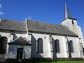 The church of Vaulx | |
Location of Vaulx | |
 Vaulx  Vaulx | |
| Coordinates: 50°16′06″N 2°05′52″E / 50.2683°N 2.0978°E / 50.2683; 2.0978 | |
| Country | France |
| Region | Hauts-de-France |
| Department | Pas-de-Calais |
| Arrondissement | Arras |
| Canton | Auxi-le-Château |
| Intercommunality | CC Ternois |
| Government | |
| • Mayor (2020–2026) | Claude Bruhier[1] |
| Area 1 | 4.92 km2 (1.90 sq mi) |
| Population | 90 |
| • Density | 18/km2 (47/sq mi) |
| Time zone | UTC+01:00 (CET) |
| • Summer (DST) | UTC+02:00 (CEST) |
| INSEE/Postal code | 62838 /62390 |
| Elevation | 35–131 m (115–430 ft) (avg. 93 m or 305 ft) |
| 1 French Land Register data, which excludes lakes, ponds, glaciers > 1 km2 (0.386 sq mi or 247 acres) and river estuaries. | |
Vaulx is a commune in the Pas-de-Calais department in the Hauts-de-France region of France.[3]
Geography
Vaulx lies 34 miles (55 km) west of Arras, at the junction of the roads D121 and C103.
Population
| Year | Pop. | ±% p.a. |
|---|---|---|
| 1968 | 129 | — |
| 1975 | 118 | −1.27% |
| 1982 | 103 | −1.92% |
| 1990 | 83 | −2.66% |
| 1999 | 83 | +0.00% |
| 2007 | 88 | +0.73% |
| 2012 | 91 | +0.67% |
| 2017 | 90 | −0.22% |
| Source: INSEE[4] | ||
Places of interest
- The church of St. Martin, dating from the eighteenth century.
- The eighteenth-century chateau.
- The seventeenth-century chapel of St. Roch.
See also
References
- ↑ "Répertoire national des élus: les maires". data.gouv.fr, Plateforme ouverte des données publiques françaises (in French). 2 December 2020.
- ↑ "Populations légales 2021". The National Institute of Statistics and Economic Studies. 28 December 2023.
- ↑ INSEE commune file
- ↑ Population en historique depuis 1968, INSEE
Wikimedia Commons has media related to Vaulx (Pas-de-Calais).
This article is issued from Wikipedia. The text is licensed under Creative Commons - Attribution - Sharealike. Additional terms may apply for the media files.