Grigny | |
|---|---|
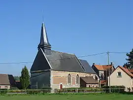 The church of Grigny | |
 Coat of arms | |
Location of Grigny | |
 Grigny  Grigny | |
| Coordinates: 50°23′08″N 2°04′02″E / 50.3856°N 2.0672°E | |
| Country | France |
| Region | Hauts-de-France |
| Department | Pas-de-Calais |
| Arrondissement | Montreuil |
| Canton | Auxi-le-Château |
| Intercommunality | CC des 7 Vallées |
| Government | |
| • Mayor (2020–2026) | Francis Maniez[1] |
| Area 1 | 2.14 km2 (0.83 sq mi) |
| Population | 294 |
| • Density | 140/km2 (360/sq mi) |
| Time zone | UTC+01:00 (CET) |
| • Summer (DST) | UTC+02:00 (CEST) |
| INSEE/Postal code | 62388 /62140 |
| Elevation | 25–85 m (82–279 ft) (avg. 31 m or 102 ft) |
| 1 French Land Register data, which excludes lakes, ponds, glaciers > 1 km2 (0.386 sq mi or 247 acres) and river estuaries. | |
Grigny (French pronunciation: [ɡʁiɲi] ⓘ) is a commune in the Pas-de-Calais department in the Hauts-de-France region of France.[3]
Geography
A village situated at the edge of the forest of Hesdin, some 13 miles (21 km) southeast of Montreuil-sur-Mer on the D94E1 road.
Population
| Year | Pop. | ±% p.a. |
|---|---|---|
| 1968 | 383 | — |
| 1975 | 399 | +0.59% |
| 1982 | 375 | −0.88% |
| 1990 | 361 | −0.47% |
| 1999 | 329 | −1.03% |
| 2007 | 298 | −1.23% |
| 2012 | 298 | +0.00% |
| 2017 | 296 | −0.13% |
| Source: INSEE[4] | ||
Places of interest
- Church of St. Gertrude, dating from the seventeenth century.
See also
References
- ↑ "Répertoire national des élus: les maires". data.gouv.fr, Plateforme ouverte des données publiques françaises (in French). 2 December 2020.
- ↑ "Populations légales 2021". The National Institute of Statistics and Economic Studies. 28 December 2023.
- ↑ INSEE commune file
- ↑ Population en historique depuis 1968, INSEE
External links
Wikimedia Commons has media related to Grigny (Pas-de-Calais).
- Statistical data, INSEE
This article is issued from Wikipedia. The text is licensed under Creative Commons - Attribution - Sharealike. Additional terms may apply for the media files.